Portland Underhill to Wyke Regis FCRM Project

Portland Underhill to Wyke Regis FCRM Project

Portland Underhill to Wyke Regis Flood and Coastal Risk Management (FCRM) Project

    Working in partnership to define the long-term (100 year) sustainable, adaptable and integrated approach to coastal flood and erosion risks. 

    Project overview

    There are currently a number of increasing pressures on coastal management in the project area, which are expected to worsen with climate change and sea level rise. These include:  

    • Aging assets and infrastructure 
    • Chesil beach is migrating back into the Fleet / Portland Harbour due to overtopping events and front face erosion 
    • Land instability around Chesil Cove and the West Weares  
    • The risk posed by sea level rise and climate change to the A354 causeway road from both the Lyme Bay and Portland Harbour sides.  
    • The impacts of climate change on coastal processes and water levels will become increasingly harder to predict.   

    Dorset Council, working in collaboration with the Environment Agency and with support from BCP Council, Dorset Coast Forum and technical consultants AECOM, are undertaking a project to develop a new Flood and Coast Risk Management (FCRM) Strategy for the area shown in the map. 

    The new FCRM Strategy will define the long-term (100 year) sustainable, adaptable, and integrated approach for managing the risks of coastal flooding, erosion and land-sliding, taking into account the latest data and evidence.

    Find out more about the project and get involved here >> Portland Underhill to Wyke Regis Flood and Coastal Risk Management (FCRM) Strategy project

    #CoastalInnovation #CoastalConnection
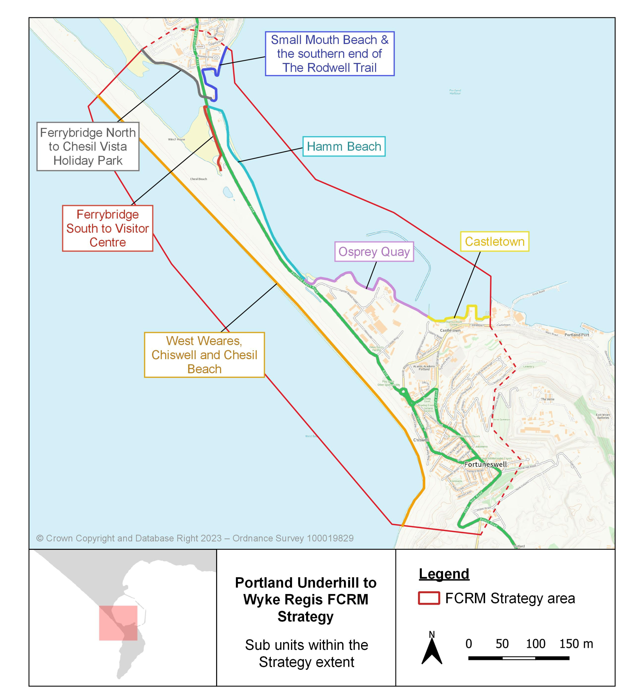
    Portland Underhill to Wyke Regis FCRM Strategy project extent and key locations

    Who’s listening?

    Matthew Smith

    Matthew Smith

    Dorset Coast Forum Project Officer

    Portland Underhill to Wyke Regis Flood and Coastal Risk Management (FCRM) Project

    Lyme Regis Cobb Stabilisation Scheme

    Lyme Regis Cobb Stabilisation Scheme

    Lyme Regis Cobb Stabilisation Scheme

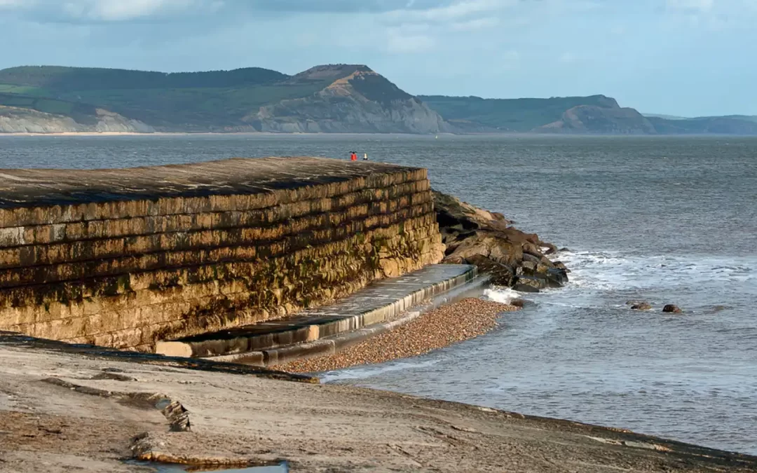
      The scheme aims to reinforce and repair the Cobb, a historic Grade 1 listed harbour. The harbour is essential as a historic monument, a breakwater that protects the town and coastline from erosion and flooding, and as the site of numerous businesses and livelihoods.  

      Project overview

      Sea-floor erosion, combined with the localised movement of stone blocks due to wave impact on the outer harbour wall and the deterioration of the structure on the inner harbour wall, have seen significant destabilisation of the structure.

      It is predicted that the functionality of the Cobb as a breakwater would end in the 2040’s, potentially resulting in the loss of the harbour, and over 100 residential and non-residential properties will be at increased risk of flooding and coastal erosion.

      The project aims to stabilise the Cobb to maintain its status as a breakwater, a coastal flood and erosion defence and a safe harbour for many different types of vessels and businesses.

      It is being proposed to strengthen and stabilise the structure which may include construction of a low-level concrete toe foundation strengthening wall along with tension piles to anchor the inner harbour walls.

      Design options have been extensively reviewed by the project team and the wider statutory authorities including Historic England, Marine Management Organisation, and the Environment Agency. The project team are currently reviewing the scheme design options with a view to come to a preferred option that can be presented to stakeholders and the public. The preferred design will have a material effect upon construction timeline and therefore the project team is not in position to comment upon the construction programme at this time.

      Visit here for more information and project updates >> Lyme Regis Cobb Stabilisation Scheme


       #CoastalInnovation #CoastalConnection

      Who’s listening?

      Matthew Smith

      Matthew Smith

      Dorset Coast Forum Project Officer

      Find out more about Lyme Regis Cobb Stabilisation Scheme

      Swanage Town Coastal Protection Scheme

      Swanage Town Coastal Protection Scheme

      Swanage Town Coastal Protection Scheme

      Working in partnership to help protect the town of Swanage from the risks of coastal flooding.

        Project updates

        No Results Found

        The page you requested could not be found. Try refining your search, or use the navigation above to locate the post.

        Project overview

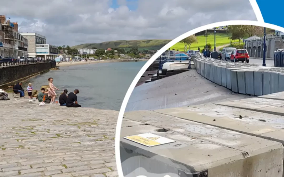
        In storm events or high tide and easterly winds, the town centre’s current defences suffer from waves overtopping the sea wall. This is an ongoing issue and has diverse implications for Swanage, impacting the environment, businesses, and tourism.  The impacts of these events on Swanage have demonstrated the need for improved protection. 

        Dorset Council in partnership with the Environment Agency, Dorset Coast Forum and Swanage Town Council are looking at options for coastal flood defences to help protect the town of Swanage.  

        The scheme aims to provide a permanent flood defence scheme to Shore Road and the Mowlem Slipway area, The Square, The Parade and Lower High Street. This central location currently relies on seasonal emergency temporary flood defences which are deployed each winter by the Environment Agency to help protect the town from high tides and storms.   

        Dorset Council’s Flood & Coastal Erosion Risk Management Team (FCERM), supported by JBA Consultants are leading the progression of a single scheme and an outline business case which will be submitted to the Environment Agency to bid for government funding for the scheme.   

        If funding is obtained, there will be further consultation with community and specific groups as the project develops. Design proposals for the flood protection scheme will be shared through direct contact, structured workshops and open community consultation events led and facilitated by Dorset Coast Forum on behalf of the project.  

        #CoastalInnovation #CoastalConnection

        Who’s listening?

        Dorset Coast Forum

        Dorset Coast Forum

        Find out more about Swanage Town Coastal Protection Scheme

        Studland Bay Marine Partnership

        Studland Bay Marine Partnership

        Studland Bay Marine Partnership

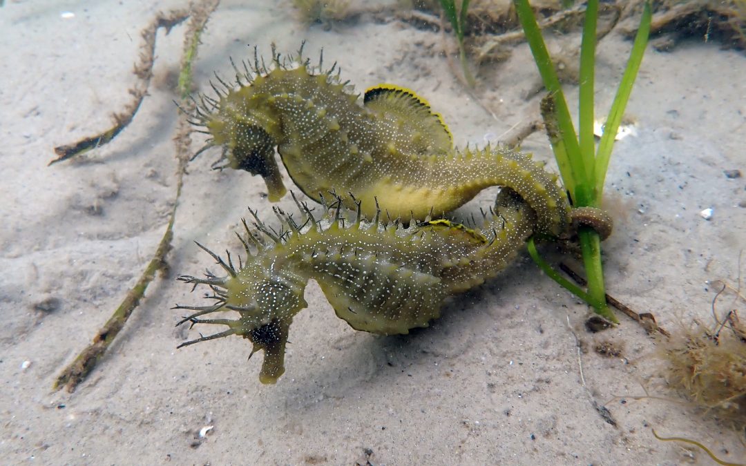
        Studland Bay is home to rare seagrass meadows. This hidden underwater world sustains hundreds of marine species, including seahorses. As a partnership, we are working to protect this fragile habitat, while enabling boaters to continue enjoying the bay.

        Project overview

        The Studland Bay Marine Partnership brings together conservation charities, boating organisations, academics, statutory bodies, community groups and local businesses.

        Together, we all share one clear goal – to restore the bay’s seagrass meadows and the wildlife they support, while ensuring boaters can continue to enjoy its calm waters.

        The Studland Bay Marine Partnership (SBMP) formed to work towards protecting Studland’s resident, and protected, long-snouted seahorse population and other marine wildlife. Dorset Coast Forum supports the partnership by coordinating engagement activities, responding to enquiries, and providing administrative support.


        Marine Conservation Zone

        Studland Bay became a Marine Conservation Zone in 2019 to safeguard its seagrass meadows and spiny seahorses that depend on them. To help protect these sensitive habitats, the Marine Management Organisation (MMO) introduced a Voluntary No Anchor Zone in 2021. Within this area, boaters are encouraged to avoid anchoring to help prevent damage to seagrass beds. The zone extends from Middle Beach and South Beach towards Old Harry Rocks. Anchoring is still permitted in emergency situations.

        For more information from the MMO see:


        Eco-moorings

        During the boating season, 87 eco-moorings are available for visiting vessels. Paying to use an eco-mooring helps protect Studland’s fragile seagrass meadows. All money raised by the mooring fees goes directly back into the conservation project.

        Unlike traditional moorings, eco-moorings are designed to minimise impact on the seabed. Each mooring uses a helical screw anchor connected to the buoy by an elastic rode that moves with the tide, helping to prevent damage to seagrass and other marine habitats.

        Visit the Studland Bay Marine Partnership website for more information on how to pay to moor, donate to the project and support Studland’s seagrass meadows. 

        Who’s listening?

        Nikki Parker-Goadsby

        Nikki Parker-Goadsby

        Support Officer, Dorset Coast Forum

        Visit the Studland Bay Marine Partnership website

        Weymouth FCERM Scheme

        Weymouth FCERM Scheme

        Weymouth Harbour and Esplanade Flood and Coastal Erosion Risk Management Scheme

        Working in partnership to help protect Weymouth from flood risks and coastal erosion

          Project overview

          As a low-lying coastal town, Weymouth is at risk of coastal flooding and erosion from the sea and flooding from surface water and the river. If a severe weather event takes place in Weymouth, thousands of homes and businesses could be flooded.

          In accordance with climate change predictions (UKCP18), sea levels are rising, and extreme weather events will happen more often and may be more severe. It is predicted that in 100 years, the average sea level can be more than one metre higher than it is today. This means that all high tides and low tides will be one meter higher, too.

          As part of the Weymouth Harbour and Esplanade Flood and Coastal Erosion Risk Management (FCERM) Scheme, Dorset Council is working with Dorset Coast Forum, the Environment Agency, Wessex Water, BCP Council and WSP (engineering consultants), to develop an Outline Business Case (OBC).

          An OBC is a document required by the UK Government Treasury when government funds are requested. The OBC will investigate costs and benefits of a range of options, then recommend the preferred options to improve Weymouth’s resilience to flood and erosion risks.

          This OBC project will build on earlier work carried out by Dorset Council and the Environment Agency exploring possible options for managing flood and erosion risk in Weymouth. The earlier work recommended a phased approach to improve resilience in three stages:

              • up to 2042
              • up to 2062
              • up to 2122 and beyond

          The OBC being produced will apply for funding for the first phase of work to take the project up to 2042. It will prioritise sections of harbour walls that are currently lower, or close to the end of their design life, and sections identified along the esplanade which are at the most risk of erosion.

          Managing impacts associated with any proposed improvements is a key consideration. These include minimising disruption as far as practicable to businesses, harbour operations, residents, and the community of Weymouth, and managing impacts on fisheries and the environment.  As part of the project, we will also be delivering exciting new regeneration opportunities for Weymouth.

          Find out information at >> Weymouth Harbour and Esplanade FCERM Scheme

           #CoastalInnovation #CoastalConnection

          Who’s listening?

          Matthew Smith

          Matthew Smith

          Dorset Coast Forum Project Officer

          Find out more about Weymouth Harbour and Esplanade FCERM Scheme