
Portland Underhill to Wyke Regis Flood and Coastal Risk Management (FCRM) Project

Working in partnership to define the long-term (100 year) sustainable, adaptable and integrated approach to coastal flood and erosion risks.

Project overview
There are currently a number of increasing pressures on coastal management in the project area, which are expected to worsen with climate change and sea level rise. These include:
- Aging assets and infrastructure
- Chesil beach is migrating back into the Fleet / Portland Harbour due to overtopping events and front face erosion
- Land instability around Chesil Cove and the West Weares
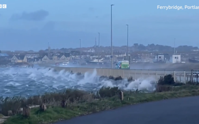
- The risk posed by sea level rise and climate change to the A354 causeway road from both the Lyme Bay and Portland Harbour sides.
- The impacts of climate change on coastal processes and water levels will become increasingly harder to predict.
Dorset Council, working in collaboration with the Environment Agency and with support from BCP Council, Dorset Coast Forum and technical consultants AECOM, are undertaking a project to develop a new Flood and Coast Risk Management (FCRM) Strategy for the area shown in the map.
The new FCRM Strategy will define the long-term (100 year) sustainable, adaptable, and integrated approach for managing the risks of coastal flooding, erosion and land-sliding, taking into account the latest data and evidence.
Find out more about the project and get involved here >> Portland Underhill to Wyke Regis Flood and Coastal Risk Management (FCRM) Strategy project
#CoastalInnovation #CoastalConnection
")
Portland Underhill to Wyke Regis FCRM Strategy project extent and key locations
Who’s listening?

Portland Underhill to Wyke Regis Flood and Coastal Risk Management (FCRM) Project